
What is Gaussian Splatting and Why Should SketchUp Users Care?
From scan to SketchUp: why reality capture changes the design conversation — notes from the Jameson project at the Castle of Good Hope, Cape Town.
1. What is Gaussian splatting?
If I had to describe it to a client in one sentence, a Gaussian splat is a 3D photograph, reality captured at a moment in time, that can be inserted into 3D modelling software to act as a backdrop and a source of truth for designing inside a real space.
Technically, instead of building a mesh of polygons, the software fills the space with millions of tiny, semi-transparent blobs of colour - the "splats." Individually, they look like nothing. Together, they reconstruct the room, the courtyard, the light, and the atmosphere with a realism that traditional 3D models rarely reach.
The important part for designers is this: a splat is not a drawing of the site. It is the site, held in your software, ready to be moved through, questioned, and designed within.
2. How is it different from photogrammetry, NeRF, and LiDAR?
Photogrammetry builds a model from photographs. Where it wins is realism: the photographic quality of how something looks, especially if you shoot with a DSLR and go in for absurdly high detail across high quantities of photographs. Where it does not win is geometry: for the geometry to be truly accurate, it needs a LiDAR scan behind it.
NeRF (Neural Radiance Fields) was the first wave of "photos to fly-through scene," but it was really slow to render and far more difficult to work with - you had to transition from the earlier photogrammetry builds, using tools like Reality Capture from Epic Games or Postshot, and then apply the result in a Blender-like environment. Gaussian splatting largely replaced it because splats render in real time.
LiDAR measures the site directly with a laser. On the Lixel K2, that means a total scanning distance of around 40 to 50 metres, with advertised accuracy of about 20 mm at 10 metres, and in the factory data sheets I have seen, generally between 6 and 12 mm. The accuracy is slightly better than normally advertised, which is the right way around: rather underpromise and overdeliver.
In practice, these are not competitors. They are different, unique workflows, and Gaussian splatting using LiDAR and photogrammetry together is the hybrid solution. The hybrid gives us accuracy while also providing a photorealistic environment. The LiDAR scan gives you trust in the dimensions. The splat gives you the feeling of standing in the room: the reality of it, here and now.
3. Why SketchUp users should care: splats are now native
For years, reality capture data lived in specialist software, and SketchUp users worked from exports and screenshots.
That has changed. SketchUp's Gaussian Splats extension, released through SketchUp Labs on the Extension Warehouse, lets you import a splat directly into your model, then crop, orient, scale, and position it with dedicated tools. Three display modes let you trade quality for speed: Rendering mode for full realism, Modelling mode for snapping to individual splats, and Point Cloud mode for fast navigation. V-Ray for SketchUp renders splats alongside your modelled geometry.
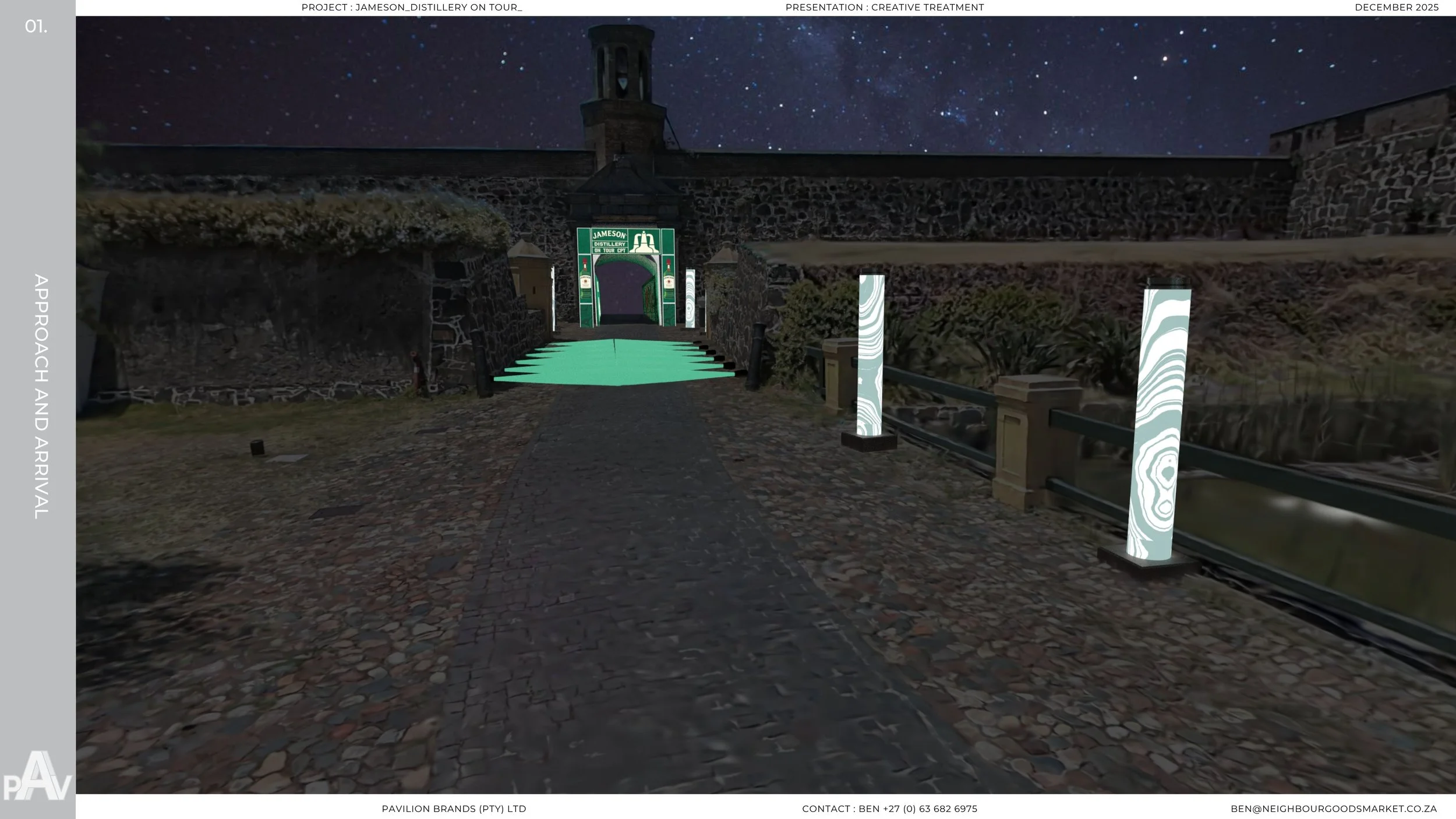
A few practicalities: you need SketchUp 2024 or newer on an active subscription, and the extension is Windows-only at launch. In our studio, which has not been a real obstacle, we run both Windows and Apple machines, so one Windows machine owns the splat workflow, and because .skp files are compatible with either operating system, the model moves freely from there.
What I particularly like is how non-destructive splat editing is inside SketchUp. You can select part of a splat, cut it, hide it, unhide it to reintegrate it later, or duplicate a scanned section if you want to reuse it. That is more forgiving than editing upstream, where not every change survives the export.
4. What this changes: the site stays present while you design
One of the biggest shifts for me in working with reality capture was realising that I no longer had to rebuild every site from scratch.
At first, that sounds like a technical advantage. It saves modelling time. It gives you more information. It gives the team a better reference point.
But the real change is deeper than that. It changes the way you think about the site.
Previously, a large part of the early design process involved redrawing context. We would work from photographs, plans, elevations, site notes, rough measurements, and whatever information the client was able to provide. From there, we would rebuild enough of the environment to begin designing.
With reality capture, the context is already there. The site remains present in the design process.
I can revisit the site mentally without physically being there. I can move around the captured environment, return to specific views, check proportions, understand adjacencies, and model new design ideas inside the real architectural context.
Instead of creating something that feels like an architectural parasite attached to an existing site, I can design in conversation with what is already there. It allows me to ask better design questions. How does this idea sit within the existing space? How does it complement what is already there? How does it work with the movement of the site rather than against it?
What a scan gives you that a photo cannot
A photograph is useful. A plan is useful. An elevation is useful. But none of them allow you to move through the site in the same way a scan does.
Inside a scan, I can position myself almost anywhere. I can stand at the entrance and look forward. I can turn around and understand what is behind me. I can drop down low, almost as if I am sitting on the floor, and view the environment from a completely different perspective. I can also zoom out and look at the site almost like a bird, reading it as a plan, an elevation, and a spatial experience at the same time.
That flexibility brings clarity. I am not relying only on what I remember from the site visit or what the camera happened to capture on the day.
A real example: Jameson at the Castle of Good Hope
The client initially supplied us with a file that appeared to be scaled to roughly a third of the real size. We thought some of this might be rectified using Google Earth or OpenStreetMap. Those tools can help with the approximate external footprint of a building, but they do not give you the interior reality of a site.
That is where the scan became incredibly useful. The captured data gave us a much clearer understanding of the interior, the courtyard, the empty pond area, the relationship between the pond and the seating area, and the level changes between the interior, courtyard, and bridge entrance.
And it directly changed the design. Our early concept moved visitors through a series of tunnels from zone to zone — an entrance zone to familiarise yourself with the project, a media and entertainment zone, and a select reserve zone for tasting Jameson's range. On a plan view over a Google Earth image, this looked beautiful. Inside the scan, we recognised how far you actually had to walk between zones.
So we optimised. Even though the architecture was set in stone, we removed one of the secluded secret areas from the plan, centralised the tasting experience closer to the main event area, and deliberately left the transition spaces between entrance and event area less populated with experiential marketing — so that you are drawn towards the event rather than lingering too long in between.
If the context is wrong, the design response quickly becomes wrong as well. The scan moved us from guessing to knowing.
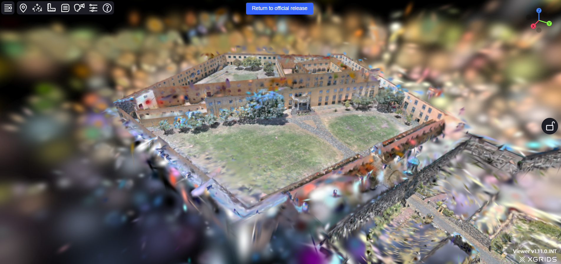
5. The workflow: from site walk to SketchUp
Our capture kit is a Lixel handheld LiDAR scanner. I have worked with both the K1 and the K2, and the K2 is the one I would choose today: it balances scanning accuracy with photographic quality, and those two facets are exactly what you need to produce both a point cloud and a good Gaussian splat. The choice comes down to price, quality, and ease of use — the K1 is being phased out, and the L2 Pro's extra accuracy is not required for shopfitting or outdoor eventing. (I have not scanned with the PortalCam yet, but the test data I have seen from it is great.)
The chain looks like this:
Capture on site. The Castle took about two hours to scan. Scanning still requires knowledge and care — pace, lighting, trajectory, coverage. You cannot simply walk through a site quickly and assume the data will be useful.
Offload via USB into Lixel's CyberColor Studio. Copy the file onto your desktop or a project folder first — reading from your SSD is faster than letting the software read off the scanner.
Process locally, overnight. We compute scans on a machine with an RTX 3080 Ti and 64 GB of RAM. At the end of the day I switch everything in the office off except that computer; by morning the scan is done. Most scans take two to six hours. For retail work we always process on slow mode — that is where the image quality is best.
Export for SketchUp. The scanner's native output is a LAS file — the standardised LiDAR format (ASPRS) that stores XYZ coordinates with RGB values, compressed as LAZ. You can pull LAS into CloudCompare or even straight into SketchUp, but it is not optimised for that. We export a PLY or LCC2 file and bring that into SketchUp through the Gaussian Splatting plugin.
Clean up. We use SuperSplat or similar for cleanup. One caution: not every change you make in CyberColor Studio is saved into the export — the software protects the parent file data. Which is another reason I prefer doing the fine editing non-destructively inside SketchUp: cut, hide, unhide, duplicate.
A note on timing: the Castle scan took six to eight hours to process, longer than usual, because we were on CyberColor 1.6 at the time (late 2025). Since upgrading to version 2 and keeping the scanner firmware current, scan sizes have come down, processing is faster, and splat quality has gone up. Keep your firmware updated — it genuinely matters.
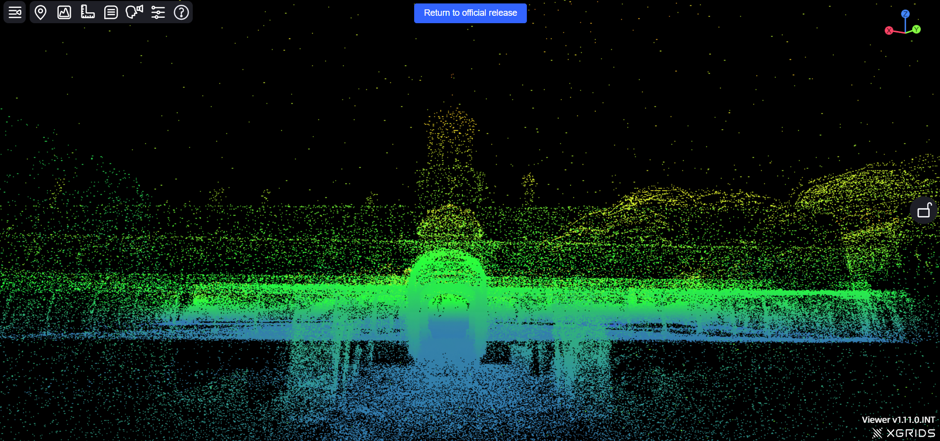
Don't have a scanner? You can start with your phone. Apps like Luma AI, Polycam, and RealityScan Mobile will produce a usable splat from video — enough to experience designing inside a captured space before committing to LiDAR hardware.
6. Where this helps retail and spatial design specifically
The client conversation
Working from a scan changes the conversation with the client because it allows them to see the concept in the environment where it will actually exist. That is a very different experience from looking at a design floating in isolation.
On the Jameson project, the client was intrigued that what we showed them — even in the early conceptual pages of the design book — was a one-for-one translation of the real Castle. It made the design feel achievable. Then on launch day they stood inside the built event and recognised the exact context we had designed in. Everything we had planned for and sold them on was physically established.
That did something no render alone can do: it showed them the transparency and authenticity of working with us. We had shown them something and then created it. We had not sold them a dream and then given them a nightmare.
This is especially valuable in spatial and retail design, where decisions are made around flow, visibility, product placement, scale, customer movement, access, and atmosphere. The scan reduces the amount of imagination required from the client and increases the amount of shared understanding in the room.
The design team
Junior designers or team members who were not present at the original site visit can still revisit the captured environment. They can understand the space, the movement, the proportions, and the existing conditions with far more clarity than photographs alone.
This matters because design teams often work from incomplete memory. One person went to site. Another received the photos. Someone else opens the CAD file. Another starts modelling. Along the way, assumptions enter the process.
A scan reduces those assumptions. It gives the team a shared spatial reference and keeps the project grounded in the real environment, even when the team is no longer physically there.
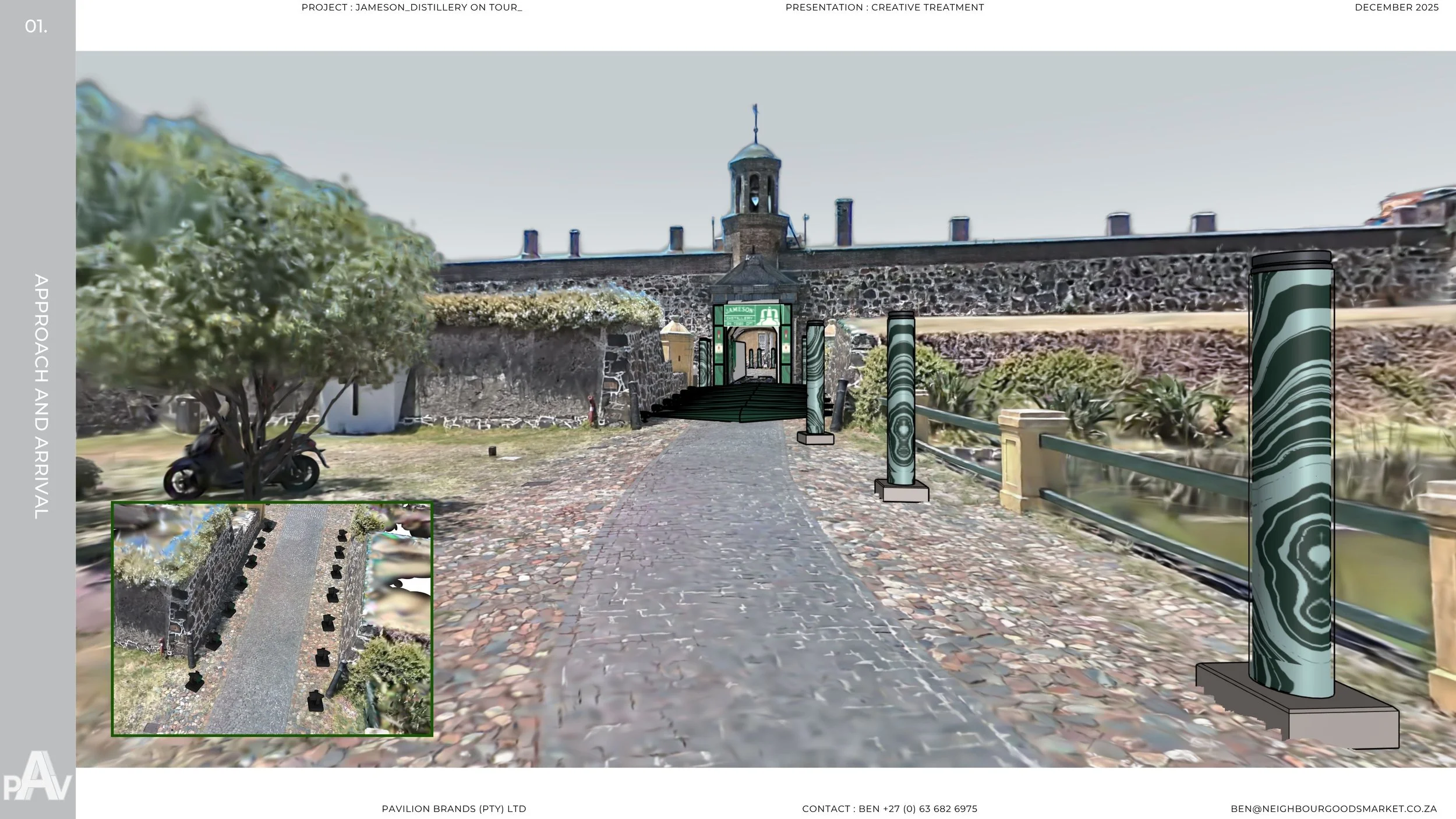
Does it actually save time?
It depends which way you work it.
If we do not need a BIM-style digital twin of the space, the splat is the context and we simply draw the new elements into it. That saves us about a week of modelling on a typical project.
If the project needs an as-built digital twin — a technical reference for installers and third-party suppliers — the scan's accuracy gives us enough material to draw one, and that adds about a week. The difference is that the week now produces something trustworthy rather than something assumed.
Why SketchUp still matters
Reality capture does not make SketchUp less important. In many ways, it makes SketchUp more powerful.
SketchUp remains the place where we develop the design concept. It is still where we model, test, simplify, communicate, and explore what the project could become. The difference is that the concept can now be seen inside the captured reality of the site.
The scan gives us the "what is." SketchUp helps us develop the "what is to come." Together, they create a much richer design environment.
7. The honest limits
There are still frustrations in the workflow.
The hardware is a serious investment. North of R130,000 for the scanner setup — not inexpensive for a small design studio, although the K1 previously sat around R160,000, so the newer K2 is actually the cheaper entry point. But across the last half year it has carried more than ten projects, and the maths has changed: if a site is hundreds of kilometres away, a good scan reduces repeated travel, saves time, limits uncertainty, and gives the team a stronger shared understanding of the environment.
Software back-and-forth. This was the single most frustrating part of the Castle workflow. At the time, V-Ray was the only rendering engine that could use the splat — and V-Ray is excellent — but our day-to-day rendering happens in D5 because it is real-time and easier to control. As of now, D5 and Enscape have not integrated Gaussian splats yet. If you are comfortable in the V-Ray environment, rendering splats through it has been really successful and we can highly recommend it.
Scan strategy matters. Where accuracy fell short at the Castle was in the asymmetrical tunnels through the walls — sections we ended up needing in high detail. We should have scanned those areas separately at high detail, with an overall scan of the Castle for walkthroughs and animation. Next time we will segment our scans that way: high-detail captures for critical sections, one overall capture for context.
A splat is not a survey. Lixel's official accuracy figures are better — the data sheets suggest 6 to 12 mm — but in our field experience you should work on being about 20 millimetres off. If you keep in mind that everything has a 20 mm variation, you are starting off safe rather than sorry. Shopfitting already has an answer for this: filler boards and spacer margins. If the cutout is 2.5 metres, make the unit 2.46 metres; if the unit is 2.5 metres, the cutout wants to be 2,540 millimetres. The margin also leaves room for hand-guided cable reticulation — lighting and data — after the object is installed. Design the tolerance in, and the 20 millimetres never becomes a site problem.
Processing takes planning. Slow mode overnight is our rhythm. It is not a blocker, but it is a discipline.
8. Where this is heading
Reality capture is often seen as something that belongs to surveyors, construction teams, or technical specialists. I understand why — the language of LiDAR, point clouds, trajectories, and processing can feel highly technical. But I do not think reality capture belongs only in that technical world.
For me, architecture and spatial design are always held in balance between what is and what is to come. A good design proposal does not exist outside its context. It responds to it, works with it, challenges it where necessary, and adds something meaningful to what is already there.
Over the next two years, I think we will see a major improvement in both quality and usability. The hardware will improve. Camera quality will improve. The alignment between LiDAR data and photographic data will become cleaner. The connection between scan data, SketchUp, and the wider design ecosystem will become simpler. I expect rendering tools such as V-Ray, D5 Render, and Enscape to work more closely with Gaussian splats, allowing designed models and captured environments to feel like one seamless whole.
Two developments I am specifically anticipating:
Shared splats as project infrastructure. Something like Trimble Connect hosting the Gaussian splat so every third-party supplier can place their designed elements inside the same captured context. The scan stops being a studio asset and becomes the project's common ground.
AI-generated as-builts. I expect software to understand more of what it is looking at — a road surface, a parked vehicle, a tree, a shopfront, a window, a door, a piece of furniture becoming identifiable and editable inside the scan. In some ways this may begin to feel like IFC classification for captured reality: the scan converting itself into an as-built digital twin, overlaying a SketchUp model onto the LiDAR and splat data, and alleviating us from drawing it out. We already see this direction in tools like Photoshop, where AI infill removes or extends image content. A similar logic applied to spatial scans would change how we clean, edit, and develop captured sites.
The next step will not only be better-looking scans. It will be smarter scans.
9. Quick answers (FAQ)
What is Gaussian splatting in simple terms? A 3D photograph — reality captured at a moment in time — made of millions of tiny colour blobs instead of a polygon mesh. You can move through it in real time and design inside it.
Can SketchUp open Gaussian splats? Yes. The Gaussian Splats extension (SketchUp Labs, Extension Warehouse) imports, crops, orients, and scales splats inside your model. SketchUp 2024+, active subscription, Windows-only at launch.
Can you measure from a Gaussian splat? Carefully. Official specs run 6–12 mm, but plan on around 20 mm of variation — design your tolerances in (filler boards, spacer margins) and pull critical dimensions from the LiDAR point cloud instead.
Do I need an expensive scanner to try this? No. Phone apps like Luma AI, Polycam, and RealityScan Mobile will produce a usable splat from video. A handheld LiDAR scanner like the Lixel K2 adds the accurate backbone that professional work needs.
How long does it take? The Castle of Good Hope took about two hours to capture and was processed overnight. Typical scans are processed in two to six hours locally on a decent GPU.
Gaussian splatting vs photogrammetry — which should a designer use? Photogrammetry for measurable, editable meshes. Splatting for the photoreal context you design within. Our workflow uses LiDAR for the backbone and the splat for the experience.
Final thought
For me, reality capture is not just about producing an impressive scan. It is about keeping the site present while we design.
It changes the relationship between memory, measurement, modelling, and decision-making. It helps the designer stay closer to the real environment. It helps the client understand the proposal in context. It helps the team work from a shared spatial reference. And, perhaps most importantly, it allows the design conversation to begin from a more honest understanding of what is already there.
That is why moving from scan to SketchUp is not just a workflow improvement. It is a change in the way we think about space.