
From Scan to SketchUp: Capturing Reality vs Rebuilding It
In our last post, What is Gaussian Splatting and Why Should SketchUp Users Care? We introduced the technology and our workflow. This post goes one layer deeper: what actually changes when you capture reality instead of rebuilding it.
1. Why is capturing reality different from rebuilding reality?
First and foremost, as a SketchUp user, the difference is time.
Capturing a site takes anywhere from five or ten minutes to three or four hours. Rebuilding that same site in SketchUp takes anything from half an hour to a full week, or more, if the site is complex.
We tend to scan areas of up to a square kilometre in roughly a day, even with indoor detail involved. We could not redraw something like that in the same day if we wanted to.
But there is a second difference, and it is more subtle.
Capturing reality also captures the nuance of a certain day. Whether it was sunny, overcast, or raining. The temperature, the shading, the time of day. All of that is baked into the scan. A reality capture is of a specific moment in time.
Rebuilding, on the other hand, lets you control the day. What you draw is an idealised site, not the site as it stood when you visited it.
Both have their place. But only one of them tells you the truth about what was there.
2. What usually gets lost when a designer works only from photos and drawings?
Start with the drawings.
Drawings are generally created at great cost at the beginning of a project, when the structure is built. If you are in a country or municipality that cares for its drawings, you can ask for as-builts. And the as-builts exist precisely because construction drawings don't always get followed completely. Walls set out slightly differently. Windows slightly off a centre line. Light fittings not installed as intended.
So if you rebuild reality from a drawing, you may find that what you have drawn is not what reality presents you with.
Then the photos. There are many ways of taking photos: phone camera, digital camera, DSLR, 360 camera, a Matterport-style rotating device, and each one is trying to capture as much data as possible. Each one trades something away. The phone and DSLR capture a specific field of view; the DSLR has an incredible sensor but can only see so much at once, so you need hundreds if not thousands of frames. The 360 camera captures everything from where you stand, but not in the detail you would hope for.
And here is the practical problem: you cannot run a structured, cohesive photographic plan while listening to your client as you walk the space, working with your team on measurements at the same time. Photos taken on a normal site visit leave holes in the survey. That is not a failure of discipline; it is the reality of a site visit.
Photogrammetry tools: RealityScan from Epic Games, Postshot, and similar reconstruction software, try to close that gap with volume: thousands of photos and enormous processing power to work out where each frame sits. Without LiDAR depth data underneath, the computer is guessing at geometry from images alone.
So what gets lost when a designer works only from photos and drawings? The most accurate, up-to-date environment, and complete, cohesive visibility of the site.
3. How does the scan change the first design conversation?
A scan captures the building in a moment in time with such clarity that the client immediately relates to it. They feel at home. They feel seen and heard in the project.
Even a really well-rebuilt site is still a recreation, the client is looking at a drawing inside a software program, rendered in the interface of that software. A scan is different. It is recognisably their building, their space, on a day they remember.
That does something to trust. When the first design conversation starts from open, transparent visibility of what exists right now, the client engages beyond what we would normally expect from a first meeting. There is a comfort and a familiarity there that a model alone does not create.
It also lets the conversation go deeper, faster. We can articulate how the context around the design enhances it or detracts from it. All those connections between the site and the object-to-be-created can be explored, and in many cases resolved, in that first conversation, rather than three meetings later.
4. When is scan data useful, and when is it unnecessary?
Scan data is useful throughout any project of any type. I will say that up front: at this point, I have not experienced an unnecessary scan.
But there is a scale at which it stops earning its keep, when the thing you need to capture is smaller than roughly a foot, or about 20 centimetres.
Why there? The capturing quality of the Lixel K2 is intense within a scan covering a 25-by-25-metre area, we can drill down to the detail of the spine of a book on a shelf. But when the subject itself is only about 20 centimetres across, that same information is easily captured by taking photos and measuring with a tape, by making a small scan with the Scaniverse app on a flagship phone, or through close-range photogrammetry.
So the honest answer: the scanner earns its place at the scale of rooms, buildings, and sites. Below that, simpler tools do the job.
5. What does this mean for site visits, audits, and as-built information?
It means a site visit can now do three things at once.
One: experience the site. We walk the site and take it in firsthand as observers, using all our senses. The Lixel, or any SLAM scanner, is merely a device you hold in your hand and pay relatively little attention to. The scanner does not replace the sensory site visit; it rides along with it.
Two: audit the data. Making sure that what you scan is accurate and cohesively captured, with enough LiDAR data. Part of this audit happens on site; the rest happens back in the office. Because the scanner lets you walk in circles, spirals, and S-shaped snaking paths, overlapping your own crossing points, you can capture the site thoroughly, from multiple directions. That overlap is what makes the dataset dense, cohesive, and secure.
Three: reconcile the as-builts. The as-built information in the drawings should now overlap with the as-built information in the LiDAR scan and the Gaussian splat. We can lay the data we collected over the as-built plans and the schematics as they were submitted to the municipality for construction, and see exactly where reality and paperwork agree, and where they don't.
The site visit becomes twofold in nature: a scanning opportunity to collect data, and a human sensory experience. The audit and the reconciliation follow from there.
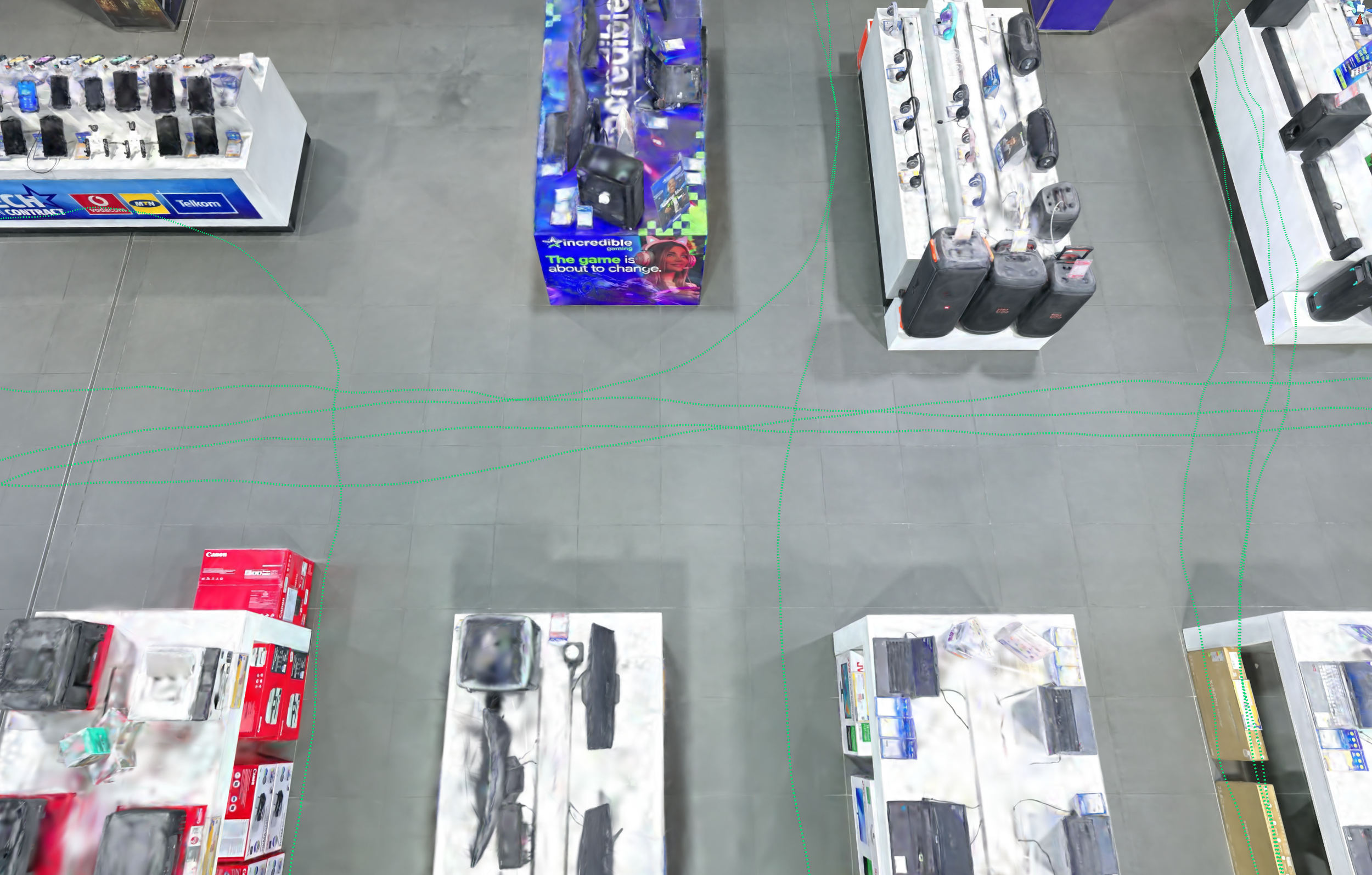
The green dotted lines indicate the scanning path
6. Final thought
That is the shape of scan-to-SketchUp thinking. Capturing is faster than rebuilding, and more honest about what a site really is. Photos and drawings — even SketchUp's own Match Photo, leave holes that a cohesive scan does not. The scan changes the first design conversation because the client recognises their own building in it. And the site visit itself has grown richer: experience, audit, and capture, all in one walk.
The scan gives us the "what is." SketchUp develops the "what is to come." This post was about getting the "what is" right.
What is Gaussian Splatting: watch it on Youtube: Gaussian Splatting in SketchUp
Next in series: Lixel K2 Workflow: What Happens After The Scan?